It has been a few weeks since I checked the NASA web page to find out how the Mars Rover, Curiosity, is doing.
On Sol 84 (Oct. 31, 2012), NASA's Curiosity rover used the Mars Hand Lens Imager (MAHLI) to capture a set of 55 high-resolution images, which were stitched together to create the above full-color self-portrait.
The mosaic shows the rover at "Rocknest," the spot in Gale Crater where the mission's first scoop sampling took place. Four scoop scars can be seen in the area in front of the rover.
The base of Gale Crater's 3-mile-high (5-kilometer) sedimentary mountain, Mount Sharp, rises on the right side of the frame. Mountains in the background to the left are the northern wall of Gale Crater. Self-portraits like this one document the state of the rover and allow mission engineers to track changes over time, such as dust accumulation and wheel wear.
In the above image, the scoop on NASA's Curiosity rover shows the larger soil particles that were too big to filter through a sample-processing sieve that is porous only to particles less than 0.006 inches (150 microns) across. After a full-scoop sample had been vibrated over the sieve, this held-back portion was returned to the scoop to be accessible for inspection by the rover's Mast Camera. The process implemented by Curiosity to sample the Martian crust involved scooping some soil, shaking it thoroughly inside the sample-processing chambers to scrub the internal surfaces, putting it through a sieve, dividing it into the appropriate portions and then discarding the sample. This process was repeated three times. The rinse-and-discard cycles serve a quality-assurance purpose similar to a common practice in geochemical laboratory analysis on Earth.
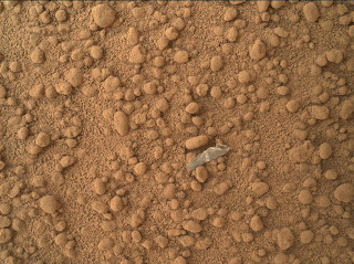
The above image shows a small bright object on the ground beside the rover at the "Rocknest" site. The object is just below the center of this image. It is about half an inch (1.3 centimeters) long. The rover team has assessed this object as debris from the spacecraft, possibly from the events of landing on Mars. I guess we are now littering another planet.
The above image shows where the Chemistry and Camera (ChemCam) instrument on NASA's Mars rover Curiosity used its laser and spectrometers to examine what chemical elements are in a drift of Martian sand during the mission's 74th Martian day, or sol (Oct. 20, 2012). The target area, called "Crestaurum," was zapped 30 times by the instrument's laser. The dark pit created by the repeated laser hits is about one-eighth of an inch (3 millimeters) across. Crestaurum is within the "Rocknest" patch of windblown dust and sand. It was selected as a target surfaced with fine-grain sand. The distance to the target from the ChemCam instrument at the top of Curiosity's mast was 8 feet and 10 inches (2.7 meters).
The Mars Hand Lens Imager (MAHLI) on the arm of NASA's Mars rover Curiosity took the above image of a rock called "Et-Then" during the mission's 82nd sol, or Martian day (Oct. 29, 2012.) The rock was named after an island in Great Slave Lake, Northwest Territories, Canada. The photo was taken from a distance of about 15.8 inches (40 centimeters). The image covers an area about 9.5 inches by 7 inches (24 centimeters by 18 centimeters). Et-Then is located near the rover's front left wheel, where the rover has been stationed while scooping soil at the site called "Rocknest."
This graphic shows results of the first analysis of Martian soil by the Chemistry and Mineralogy (CheMin) experiment on NASA's Curiosity rover. The image reveals the presence of crystalline feldspar, pyroxenes and olivine mixed with some amorphous (non-crystalline) material. The soil sample, taken from a wind-blown deposit within Gale Crater, where the rover landed, is similar to volcanic soils in Hawaii. Curiosity scooped the soil on Oct. 15, 2012, the 69th sol, or Martian day, of operations. It was delivered to CheMin for X-ray diffraction analysis on October 17, 2012, the 71st sol. By directing an X-ray beam at a sample and recording how X-rays are scattered by the sample at an atomic level, the instrument can definitively identify and quantify minerals on Mars for the first time. Each mineral has a unique pattern of rings, or "fingerprint," revealing its presence.
Photos showing what these minerals look like on Earth are below.
First, feldspar...
Pyroxene...
The semi-precious gem peridot is a variety of olivine.
This pair of images from the Mast Camera on NASA's Curiosity rover shows the
upper portion of a wind-blown deposit dubbed "Rocknest." The soil samples used to analyze the minerals in the Martian crust were taken from a region located out of frame,
below this view. The colors in the image at left are unmodified,
showing the scene as it would appear on Mars, which has a dusty red-colored
atmosphere. The image at right has been white-balanced to show what the same
area would look like under the lighting conditions on Earth.
Image and information Credits: NASA/JPL-Caltech/Malin Space Science Systems, pyroxene photo courtesy Krzysztof Pietras of Wikimedia Commons, feldspar photo shutterstock_81025396.
Friday, November 2, 2012
Subscribe to:
Post Comments (Atom)


Hiya - we met and talked at the last agate days meeting - I just found your blog and really like it. I've been keeping track of curiosity as well - they post raw pictures which can be made into stereo (3d) anaglyphs. I've posted some on flickr here: http://www.flickr.com/photos/macspics123/sets/72157631210309096/
ReplyDeletethere are also some anaglyphs of the show if you are interested..
best - colin.