
The comment requested more information about the trenches mentioned in this paragraph:
The average depth of the Atlantic is 12,880 feet (3,926 m). The greatest depth is the Milwaukee Deep at 27,500 feet (8,380 m), which is in the Puerto Rico Trench. The Atlantic's width varies from 1,770 miles (2,848 km) between Brazil and Sierra Leone to over 4,000 miles (6,400 km) in the south. There are 93 countries that border the ocean including 16 in Europe, 27 in Africa, 11 in South America, 27 in the Caribbean, and 12 in Central and North America.
I began responding to this request by taking a step back. What are the deepest points in all the world's oceans?


Deepest Point in the Atlantic Ocean
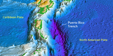
Puerto Rico Trench: -28,374 feet / -8648 meters

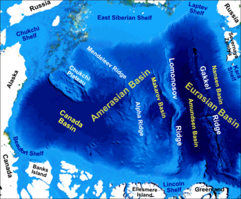
Deepest Point in the Arctic Ocean
Eurasia Basin: -17,881 feet / -5450 meters

Deepest Point in the Indian Ocean
Java Trench: -23,376 feet / -7125 meters.


Deepest Point in the Southern Ocean
Southern end of the South Sandwich Trench: -23,736 feet / -7235 meters


Puerto Rico, the United States Virgin Islands, British Virgin Islands, and the Dominican Republic do not have active volcanoes; however, they are at risk from earthquakes and tsunamis. The Puerto Rico Trench is capable of producing earthquakes greater than magnitude 8.0.
The seafloor in the region of the Puerto Rico trench is shown in detail by these images compiled by the USGS Woods Hole Science Center, shown below.


Scientific studies have concluded that an earthquake occurring along this fault zone could generate a significant tsunami. The island of Puerto Rico lies immediately to the south of the fault zone and the trench. The trench is 800 kilometres (497 mi) long and has a maximum depth of 8,648 metres (28,373 ft) at Milwaukee Deep, which is the deepest point in the Atlantic Ocean and the deepest point not in the Pacific Ocean.
The results of studies involving mapping and seismic profiling of the sea floor off Puerto Rico’s northern shore, have uncovered evidence of an enormous submarine landslide. The suspect slide extends across roughly 35 square miles, and evidence indicates that a slide of this size would have involved approximately 620 cubic miles of material!


Assuming that the slide occurred as a single event, an underwater slide of this magnitude would have generated a tsunami of frightening proportions. The effects of such a tsunami on present day Puerto Rico would be disastrous, and considering that the region is still tectonically active, an event like this could likely occur again at some point in the future.


Assuming that the slide occurred as a single event, an underwater slide of this magnitude would have generated a tsunami of frightening proportions. The effects of such a tsunami on present day Puerto Rico would be disastrous, and considering that the region is still tectonically active, an event like this could likely occur again at some point in the future.
http://geography.about.com/od/learnabouttheearth/a/extremes_3.htm
http://www.whoi.edu/cms/images/trenches_main_206853.jpeg
http://clasticdetritus.files.wordpress.com/2009/12/puertorico-seafloor2.jpg
http://www.wired.com/wiredscience/2009/12/sea-floor-sunday-58-northern-puerto-rican-margin/
http://rantzz.files.wordpress.com/2011/01/currents_hrov_en2_49157.jpg
http://ocwus.us.es/geografia-humana/handbook-on-marine-policy-in-the-us-and-the-eu-an-approach-to-emerging-issues/handbook_web/marianatrench.jpg
http://geology.com/records/deepest-part-of-the-ocean-map.gif
http://lh5.googleusercontent.com/shOSATUNPepsLON0IOPFu4HbjI3eDgI1giHDniOQINPTBSqxe9zLiS3187OSexzHaRzK0hJhgdIMvxq4BKin2NBH6_5yxJyPFmLq7TqvhH_LyHYc2i_h
https://blogger.googleusercontent.com/img/b/R29vZ2xl/AVvXsEg9B_P0UW50eWfPCKENGtAIRBHAM1JlTFpHnU1tGT1FcOgWvGwJGVmU148HTuxKDxw7EfnH1e8mxvHZRfM11CgB8Legcnym5fcO_88OwFWT8A9bBPm2wwMSR1eQ8UAEpLI8ZCctcmCWgewU/s1600/La+falla+septentrional.gif
http://taojoe.com/blog/wp-content/uploads/2011/02/Puerto-Rico-Trench.jpg
http://www.maine.gov/doc/nrimc/mgs/explore/hazards/tsunami/jan05-6.jpg
http://www.promare.org/wp-content/uploads/2012/08/Puerto-Rico-Trench-Map-6.jpg
http://modernsurvivalblog.com/natural-disasters/freak-uk-mini-tsunami-a-reminder-of-puerto-rico-trench-hazard/
http://www.conchologistsofamerica.org/articles/y1996/images/trench1.gif
http://en.wikipedia.org/wiki/Puerto_Rico_Trench
http://upload.wikimedia.org/wikipedia/commons/thumb/d/d4/Arctic_Ocean_bathymetric_features.png/350px-Arctic_Ocean_bathymetric_features.png
http://volcano.oregonstate.edu/vwdocs/vwlessons/lessons/Plates/Picture10.gif
http://www.shorstmeyer.com/msj/geo130/slide_shows/equake_all.jpg
No comments:
Post a Comment