Yesterday I worked my booth at the Escanaba show all day. Sales were so-so, unfortunately. So I didn't get a chance to take any photos. Therefore, for today's blog posting I decided to check to see what pictures of Earth from space NASA has that are interesting.
The first picture is of the Mackinac Bridge. The Bridge spans a stretch of water five miles wide between Michigan’s lower and upper peninsulas. The strait connects Lakes Michigan (left) and Huron (right). The bridge is a combination of pier-supported spans with a high, central suspension sector that allows passage of lake steamers. The suspension sector is the longest in the Americas (8, 614 feet or 1.6 miles). Prior to construction of the bridge, the only passage across the straits was by ferryboat. The photo shows shipping lanes opened by ice breakers. A narrow passage connects the cleared shipping channel to the small town of St. Ignace at the north end of the bridge (Mackinaw City appears at the south end). The April view shows the ice broken into a series of irregular rafts that appear gray against bright water. The whitish appearance of the water is not snow or ice, but instead is sunlight glinting off the water back to camera. The shipping channel is maintained even through remnants of the ice mass, but the ice ridges can be hazardous to shipping until the last of the ice breaks up.
Astronauts obtained this detailed image of the summit caldera of Mauna Loa volcano, called Mokuaweoweo Caldera. Mauna Loa is the largest volcano on our planet—the summit elevation is 4,170 m (over 13,600 ft), but the volcano’s summit rises 9 km above the sea floor. The sharp features of the summit caldera and lava flows that drain outward from the summit are tribute to the fact that Mauna Loa is one of the Earth’s most active volcanoes. The most recent eruption was in 1984. The straight line that cuts through the center of the crater from top to bottom is a rift zone—an area that pulls apart as magma reaches the surface. A weather observatory run by NOAA’s Climate Monitoring & Diagnostics Lab is on the volcano’s north slope at 11,000 ft (3397 m). This facility, known as the Mauna Loa Observatory, is the site where scientists have documented the constantly increasing concentrations of global atmospheric carbon dioxide.
Other resources about Mauna Loa:
http://wwwhvo.wr.usgs.gov/maunaloa/
http://www.cmdl.noaa.gov/obop/mlo/
The snow-covered peaks of the Alps can be seen in this near-nadir view. Cut by numerous gaps and passes, the Alps do not form a complete climax or strategic barrier, as is evidenced by the similarities of air, people, and animals on either side of the system. Permanently snow capped peaks rise above the snowline - located between 8000 and 10000 feet (2440 to 3050 meters) - and valley glaciers form the headwaters of many Alpine rivers. Glaciation was quite extensive around 13000 years ago and carved a distinctive mountain landscape of cirques, Matterhorn's, u-shaped and hanging valleys, and long moraine-blocked lakes. Below the snowline is a treeless zone of pastures that have for generations been used for summer grazing. Tourism, based on the scenic attractions of the Alps and the mountaineering and winter sports they provide, is a major source of income for the region. Near the bottom center of the image, the famous resort city of Innsbruck is discernible. The Winter Olympic Games were held in Innsbruck in 1964 and 1976.
The twin cities of Sault Ste Marie are located across the St. Mary’s River that forms part of the international boundary between Canada (Province of Ontario) and the United States (State of Michigan). This astronaut photograph highlights the two cities, together with the region of lakes and islands that separates Lakes Huron and Superior, two of the Great Lakes of North America. Smaller lakes include Lake George to the west; the large forested islands of St. Joseph and Drummond are visible at image upper left. The Sault Ste Marie urban areas (image lower left) have a distinctive gray to white coloration in the image, contrasting with the deep green of forested areas in Ontario and the lighter green of agricultural fields in Michigan. The coloration of water surfaces in the lakes and rivers varies from blue to blue-green to silver, and is likely caused by varying degrees of sediment and sun glint – light reflecting back to the astronaut observer on the International Space Station from the water surface, much as light reflects from a mirror. Prior to formalization of the US/Canada border in 1817, Sault Ste Marie was a single community. Archaeological evidence suggests that the region had been occupied by Native Americans at least five hundred years ago. A mission – the first European settlement in Michigan - was established there in 1668 by the French Jesuit Father Jacques Marquette. Today, shipping locks and canals in both urban areas are an important part of the Great Lakes shipping traffic system.
The Grand Canyon, one of the deepest canyons in the world with a depth of 1 mile (1.6 kilometers), can be seen in this spectacular, west-looking, low-oblique photograph. The Colorado River cut through rocks billions of years old to create this canyon. The Grand Canyon is 277 miles (466 kilometers) long and averages nearly 10 miles (16 kilometers) in width. The snow-covered, forested Kaibab Plateau (north of the canyon) and the Coconino Plateau (south of the canyon) are visible. The western portions of the Painted Desert can be seen east of the canyon where the Little Colorado River joins the Colorado River.
And the skies of night were alive with light, with a throbbing, thrilling flame; Amber and rose and violet, opal and gold it came. It swept the sky like a giant scythe, it quivered back to a wedge; Urgently bright, it cleft the night with a wavy golden edge. — “The Ballad of the Northern Lights.”
In describing auroras as he saw them in the far north in 1908, poet Robert Service captured the sense of fluid motion, the vivid color, and the fiery, flame-like qualities one sees from the ground. His description works just as well in the southern hemisphere and when looking down from above.
Astronauts on the International Space Station (ISS) used a digital camera to capture several hundred photographs of the aurora Australia, or “southern lights,” while passing over the Indian Ocean on September 17, 2011. Solar panels and other sections of the ISS fill some of the upper right side of the photograph. Auroras are a spectacular sign that our planet is electrically and magnetically connected to the Sun. These light shows are provoked by energy from the Sun and fueled by electrically charged particles trapped in Earth’s magnetic field, or magnetosphere. In this case, the space around Earth was stirred up by an explosion of hot, ionized gas from the Sun—a coronal mass ejection—that left the Sun on September 14, 2011. The pressure and magnetic energy of the solar plasma stretches and twists the magnetic field of Earth like rubber bands, particularly in the tail on the night side. This energizes the particles trapped in our magnetic field; that energy is released suddenly as the field lines snap the particles down the field lines toward the north and south magnetic poles. Fast-moving electrons collide with Earth’s upper atmosphere, transferring their energy to oxygen and nitrogen molecules and making them chemically “excited.” As the gases return to their normal state, they emit photons, small bursts of energy in the form of light. The color of light reflects the type of molecules releasing it; oxygen molecules and atoms tend to glow green, white or red, while nitrogen tends to be blue or purple. This ghostly light originates at altitudes of 100 to 400 kilometers (60 to 250 miles).
The Northern Hemisphere Jet Stream can be seen crossing Cape Breton Island in the Maritime Provinces of Eastern Canada. The Jet Stream is a narrow zone of high-speed winds typically found at altitudes of 4 to 8 miles (8-12 km) above the earth. They result from temperature contrasts between polar and tropical regions. The strongest Jet Stream winds are found in the winter when the contrast between polar and tropical regions is the greatest. Wind speeds can reach 90 to over 180 miles per hour (145 to over 290 km/h) from west to east. Jet Streams are found between latitudes 20 to near 55 north and south. During the winter months over the United States and southern Canada, the path taken by the Jet Stream can have a large influence on the weather conditions of this region.
Astronauts aboard the International Space Station took this digital photograph of the eye of Hurricane Igor at 10:56 Atlantic Daylight Time (13:56 UTC) on September 14, 2010. The storm was a category four hurricane on the Saffir-Simpson scale of intensity. At the time of the image, Igor was centered in the Atlantic Ocean near 18° N 52° W and slowly moving west-northwest at 11 kilometers (7 miles) per hour, according to the U.S. National Hurricane Center. Maximum sustained winds of 213 km (132 mi.) per hour, with gusts to 259 km (161 mi.) per hour.
Eruption of Cleveland Volcano, Aleutian Islands, Alaska is featured in this image photographed by an Expedition 13 crew member on the International Space Station. This image, acquired shortly after the beginning of the eruption, captures the ash plume moving west-southwest from the summit vent. The eruption was short-lived; the plume had completely detached from the volcano summit two hours later. Ash plumes from Cleveland Volcano have reached heights of 12 kilometers and can present a hazard to trans-Pacific jet flights. The fog bank visible at image top center is a common feature of the Aleutian volcanoes. Cleveland Volcano, situated on the western half of Chuginadak Island, is one of the most active of the volcanoes in the Aleutian Island chain extending west-southwest from the Alaska mainland. At a summit elevation of 1,730 meters, this stratovolcano is the highest in the Islands of the Four Mountains group. Carlisle Island to the north-northwest, another stratovolcano, is also part of this group. Magma that feeds eruptions of ash and lava flows from the volcano is generated by subduction of the northwestward-moving Pacific Plate beneath the North American Plate. As one tectonic plate subducts beneath another, melting of materials above and within the subducting plate produce magma that can eventually move to the surface and erupt through a vent (such as a volcano). Cleveland Volcano claimed the only known eruption-related fatality in the Aleutian Islands during 1944.
The crew of the International Space Station took this dramatic image of the fires in Australia on the morning of January 18, 2003. Brisk winds are sweeping smoke plumes eastward off the Australian coast north of Cape Howe. The agricultural valleys of the Murrumbidgee and Murray Rivers give way to the burning, darker bush areas of the mountains with the extreme eastern coastline of Victoria visible beyond. Images like these are a unique contribution to our understanding of dynamic events — made possible by the human observer in orbit.
Sunday, March 25, 2012
Saturday, March 24, 2012
Agate Detail Up Close and Escanaba Booth
I arrived in Escanaba, MI yesterday for my first show of the year. Booth set up went smoothly. Here are a couple shots of the booth.
As is typical for a Friday night show, booth traffic was light. I arrived back to my motel room and decided to play with the new USB powered camera. I had the magnification set at 60, Here are a few of the images. All of the pictures are of natural Lake Superior unpolished or cut agates.
First, an agate with botryoidal structure.
Banding on the external surface of an agate....
A conchoidal fracture showing waxy luster.
An agate with some peeler structure as well as an eye.
Nice banding...
A peeler agate....
As is typical for a Friday night show, booth traffic was light. I arrived back to my motel room and decided to play with the new USB powered camera. I had the magnification set at 60, Here are a few of the images. All of the pictures are of natural Lake Superior unpolished or cut agates.
First, an agate with botryoidal structure.
Banding on the external surface of an agate....
A conchoidal fracture showing waxy luster.
An agate with some peeler structure as well as an eye.
Nice banding...
A peeler agate....
Friday, March 23, 2012
NASA Photos
Yesterday I spent part of the day working on the rockhounding adventures, but then I headed to the museum to pack the car for my first show of the year. I'll be in Escanaba this weekend at the WLUC TV 6 art and craft show. The event is at the UP State Fairgrounds in the Butler Building. Hours are Friday 5-9, Saturday 10-6, and Sunday 11-4.
The first picture is Messier 9, which is a globular cluster of over 300,000 stars within a diameter of about 90 light-years. It lies some 25,000 light-years away from Earth, near the central bulge of our Milky Way galaxy.
These are pictures of M51, also known as the Whirlpool Galaxy. Each picture shows a supernova exploding star, which are short lived events. The supernova marked on the left was seen in 2005. The one on the right was seen in 2011.
A few days ago this Northern Lights photo was taken by Danial Lopez. Auroras are sparked by energetic particles from the Sun impacting the magnetic environment around the Earth. Resultant energetic particles such as electrons and protons rain down near the Earth's poles and impact the air. The impacted air molecules obtain excited electrons, and when electrons in oxygen molecules fall back to their ground state, they emit green light. Auroras are known to have many shapes and colors.
It was visible around the world. The sunset conjunction of Jupiter and Venus was visible last week almost no matter where you lived on Earth. Anyone on the planet with a clear western horizon at sunset could see them. This week the two are still notable, even though Jupiter has sunk below the brighter Venus. And if you look higher in the sky you can see Mars as well. Pictured below is a photo taken of the two planets that were separated only by three degrees. A faint red sunset still glowed in the background. Although this conjunction is drawing to a close, another conjunction between Venus and Jupiter will occur next May.
A week or so ago one of the baddest sunspot regions in years occurred. Active Region 1429 may not only look, to some, like an angry bird -- it has thrown off some of the most powerful flares and coronal mass ejections of the current solar cycle. The extended plumes from these explosions have even rained particles onto the Earth that have resulted in colorful auroras. Pictured below, AR 1429 was captured in great detail in the Sun's chromosphere by isolating a color of light emitted primarily by hydrogen. The resulting image is shown in inverted false color with dark regions being the brightest and hottest. Giant magnetically-channeled tubes of hot gas, some longer than the Earth, are known as spicules and can be seen carpeting the chromosphere. The light tendril just above AR 1429 is a cool filament hovering just over the active sunspot region. As solar maximum nears in the next few years, the increasingly wound and twisted magnetic field of the Sun may create even more furious active regions that chirp even more energetic puffs of solar plasma into our Solar System.
This floating ring is part of the photogenic Sombrero Galaxy, one of the largest galaxies in the nearby Virgo Cluster of Galaxies. The dark band of dust that obscures the mid-section of the Sombrero Galaxy in optical light actually glows brightly in infrared light. The above image, digitally sharpened, shows the infrared glow, recently recorded by the orbiting Spitzer Space Telescope, superposed in false-color on an existing image taken by NASA's Hubble Space Telescope in optical light. The Sombrero Galaxy, also known as M104, spans about 50,000 light years across and lies 28 million light years away. M104 can be seen with a small telescope in the direction of the constellation Virgo.
What's causing these odd rings in supernova 1987A? Twenty five years ago, in 1987, the brightest supernova in recent history was seen in the Large Magellanic Cloud. At the center of the above picture is an object central to the remains of the violent stellar explosion. Surrounding the center are curious outer rings appearing as a flattened figure 8. Although large telescopes including the Hubble Space Telescope monitor the curious rings every few years, their origin remains a mystery. Pictured above is a Hubble image of the SN1987A remnant taken last year. Speculation into the cause of the rings includes beamed jets emanating from an otherwise hidden neutron star left over from the supernova, and the interaction of the wind from the progenitor star with gas released before the explosion.
The first picture is Messier 9, which is a globular cluster of over 300,000 stars within a diameter of about 90 light-years. It lies some 25,000 light-years away from Earth, near the central bulge of our Milky Way galaxy.
These are pictures of M51, also known as the Whirlpool Galaxy. Each picture shows a supernova exploding star, which are short lived events. The supernova marked on the left was seen in 2005. The one on the right was seen in 2011.
A few days ago this Northern Lights photo was taken by Danial Lopez. Auroras are sparked by energetic particles from the Sun impacting the magnetic environment around the Earth. Resultant energetic particles such as electrons and protons rain down near the Earth's poles and impact the air. The impacted air molecules obtain excited electrons, and when electrons in oxygen molecules fall back to their ground state, they emit green light. Auroras are known to have many shapes and colors.
It was visible around the world. The sunset conjunction of Jupiter and Venus was visible last week almost no matter where you lived on Earth. Anyone on the planet with a clear western horizon at sunset could see them. This week the two are still notable, even though Jupiter has sunk below the brighter Venus. And if you look higher in the sky you can see Mars as well. Pictured below is a photo taken of the two planets that were separated only by three degrees. A faint red sunset still glowed in the background. Although this conjunction is drawing to a close, another conjunction between Venus and Jupiter will occur next May.
A week or so ago one of the baddest sunspot regions in years occurred. Active Region 1429 may not only look, to some, like an angry bird -- it has thrown off some of the most powerful flares and coronal mass ejections of the current solar cycle. The extended plumes from these explosions have even rained particles onto the Earth that have resulted in colorful auroras. Pictured below, AR 1429 was captured in great detail in the Sun's chromosphere by isolating a color of light emitted primarily by hydrogen. The resulting image is shown in inverted false color with dark regions being the brightest and hottest. Giant magnetically-channeled tubes of hot gas, some longer than the Earth, are known as spicules and can be seen carpeting the chromosphere. The light tendril just above AR 1429 is a cool filament hovering just over the active sunspot region. As solar maximum nears in the next few years, the increasingly wound and twisted magnetic field of the Sun may create even more furious active regions that chirp even more energetic puffs of solar plasma into our Solar System.
This floating ring is part of the photogenic Sombrero Galaxy, one of the largest galaxies in the nearby Virgo Cluster of Galaxies. The dark band of dust that obscures the mid-section of the Sombrero Galaxy in optical light actually glows brightly in infrared light. The above image, digitally sharpened, shows the infrared glow, recently recorded by the orbiting Spitzer Space Telescope, superposed in false-color on an existing image taken by NASA's Hubble Space Telescope in optical light. The Sombrero Galaxy, also known as M104, spans about 50,000 light years across and lies 28 million light years away. M104 can be seen with a small telescope in the direction of the constellation Virgo.
What's causing these odd rings in supernova 1987A? Twenty five years ago, in 1987, the brightest supernova in recent history was seen in the Large Magellanic Cloud. At the center of the above picture is an object central to the remains of the violent stellar explosion. Surrounding the center are curious outer rings appearing as a flattened figure 8. Although large telescopes including the Hubble Space Telescope monitor the curious rings every few years, their origin remains a mystery. Pictured above is a Hubble image of the SN1987A remnant taken last year. Speculation into the cause of the rings includes beamed jets emanating from an otherwise hidden neutron star left over from the supernova, and the interaction of the wind from the progenitor star with gas released before the explosion.
Thursday, March 22, 2012
Spring Beach -- Post 2 plus magnified images
Today I'll post the second half of the pictures to update everyone regarding the beach condition. First this photo shows a pool from the melted shore ice starting to mix with Lake Superior. The row intersecting the two is like quicksand. I took one step into the area and sunk down several inches.
Some of the shore ice that has not yet melted....
There are sections of the beach wherein the shore ice dredged rock up onto the beach and/or deposited its rocks upon melting.
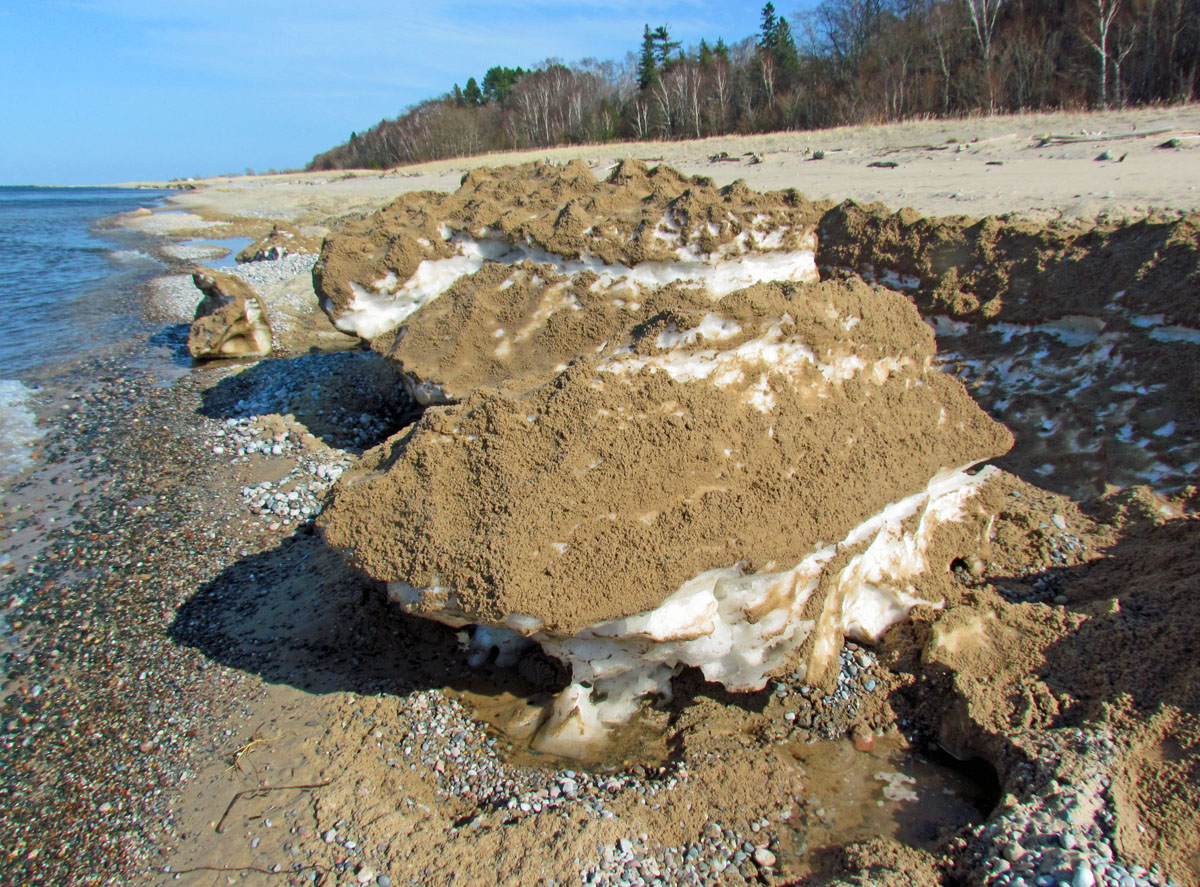
The shore ice has a lot of sand mixed in.
And then some has rock mixed in.
There is a lot more rock west of Grand Marais close to Sable River. Legally you are not supposed to rockhound in the National Park. I hear there is also a lot of rock on the beach east of Grand Marais, although I have not driven over there to check it out for myself.
The teepee is still standing tall.
Lots of rock...
I heard about USB cameras that you can plug directly into your computer. I have not spent much time with the camera, that magnifies from 20 to 200, but here are a few of the first shots I took. The first is a section of a Brazilian agate.
Then I took a couple of shots of a unpolished Ocean Jasper.
Here is a shot of petrified wood.
And a shot of the fabric in the tee shirt I was wearing.
Some of the shore ice that has not yet melted....
There are sections of the beach wherein the shore ice dredged rock up onto the beach and/or deposited its rocks upon melting.
The shore ice has a lot of sand mixed in.
And then some has rock mixed in.
There is a lot more rock west of Grand Marais close to Sable River. Legally you are not supposed to rockhound in the National Park. I hear there is also a lot of rock on the beach east of Grand Marais, although I have not driven over there to check it out for myself.
The teepee is still standing tall.
Lots of rock...
I heard about USB cameras that you can plug directly into your computer. I have not spent much time with the camera, that magnifies from 20 to 200, but here are a few of the first shots I took. The first is a section of a Brazilian agate.
Then I took a couple of shots of a unpolished Ocean Jasper.
Here is a shot of petrified wood.
And a shot of the fabric in the tee shirt I was wearing.
Wednesday, March 21, 2012
Spring Beach -- Post 1
Yesterday I decided to walk the beach and investigate the agate hunting conditions. It is unbelievable how little snow and ice are left. I'll post the pictures over two days. Over this series of 20 pictures, you will see how variable the beach is in terms of the amount of sand, rock, and still left over ice. In many places, the beach is more like an obstacle course. You also have to be careful because the ice that still remains is fragile. In several spots one of my feet fell through soft spots. Also, right next to the lake there are soft spots in the sand. I stepped in one thinking it was solid sand/rock, but it was like quicksand.
The most amazing thing is that most of the snow/ice melted in less than two weeks. The winter storm that dumped almost two feet on Grand Marais happened less than three weeks ago.
I parked at the west end of Woodland Park, walked down the west steps, headed west down the beach.
Although there is still some shore ice in spots, there is very little snow on the beach -- even at the base of the pre-Lake Superior bluff. In most years I can still ski down the beach in April. Not this year. Here is one of the few patches left, located just west of the west steps.
In front of Woodland Park, there is still some shore ice, but there are also patches of rock available. So it is now time for all of you who have been emailing me asking if there is exposed rock to come on north!
But you have to pick your spots. In some sections the shore ice melted so fast that it just dumped sand. The rocks you see to the right are those left over from the fall storms. Many agate hunters never look in this band of rock. That is a mistake since there can still be agate. One of the best agates found a few years ago was found well up the beach. There is probably rock under the sand in the following picture, but we need waves to undertow the sand back out into the lake to expose the rock.
First Creek has changed considerably in the last week. It fans out now with a large sand area next to the lake left over from peak flow, which has already finished for First Creek.
It is fairly easy to cross the creek right next to the lake.
This is a photo looking south at the beach entry source of First Creek. The mound is probably ice covered by sand (I did not investigate), but it makes it look like the creek is coming out from underground.
Here are more sand piles left over from melted shore ice.
As you walk west, there finally are some skimpy patches of rock.
In several areas, there are pools of water left over from the quick shore ice melt. The wind has been from the south for several days so these pools have not yet merged with Lake Superior.
There is still some ice melting in these pools.
The most amazing thing is that most of the snow/ice melted in less than two weeks. The winter storm that dumped almost two feet on Grand Marais happened less than three weeks ago.
I parked at the west end of Woodland Park, walked down the west steps, headed west down the beach.
Although there is still some shore ice in spots, there is very little snow on the beach -- even at the base of the pre-Lake Superior bluff. In most years I can still ski down the beach in April. Not this year. Here is one of the few patches left, located just west of the west steps.
In front of Woodland Park, there is still some shore ice, but there are also patches of rock available. So it is now time for all of you who have been emailing me asking if there is exposed rock to come on north!
But you have to pick your spots. In some sections the shore ice melted so fast that it just dumped sand. The rocks you see to the right are those left over from the fall storms. Many agate hunters never look in this band of rock. That is a mistake since there can still be agate. One of the best agates found a few years ago was found well up the beach. There is probably rock under the sand in the following picture, but we need waves to undertow the sand back out into the lake to expose the rock.
First Creek has changed considerably in the last week. It fans out now with a large sand area next to the lake left over from peak flow, which has already finished for First Creek.
It is fairly easy to cross the creek right next to the lake.
This is a photo looking south at the beach entry source of First Creek. The mound is probably ice covered by sand (I did not investigate), but it makes it look like the creek is coming out from underground.
Here are more sand piles left over from melted shore ice.
As you walk west, there finally are some skimpy patches of rock.
In several areas, there are pools of water left over from the quick shore ice melt. The wind has been from the south for several days so these pools have not yet merged with Lake Superior.
There is still some ice melting in these pools.
Subscribe to:
Posts (Atom)