Thursday, January 31, 2013

Frozen Bay and Shoreline -- Post 2

For the first time in several years, yesterday we definitely had a blizzard.  For most of the day the snow just kept coming.  It was so windy that it is hard to tell how much snow we received.  The snow drift in front of my kitchen window increased at least a foot -- maybe more. 

But for today's posting, I'll include the rest of the photos I took two days ago.   First a few photos taken from the end of Coast Guard Point.


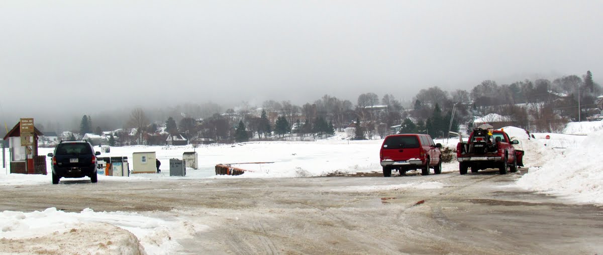
As I drove by the marina, I stopped and snapped a couple of photos of the fish shanties that locals set up right next to the marina.


Next I headed to the boardwalk.  Jonathan -- this photo is for you.  It shows the end of the platform where my son and daughter-in-law were married.


It was very foggy, so this winter beach scene shows a limited view.


Beach ice....


Dune grass....


ONLINE ROCKHOUNDING ADVENTURE UPDATE
Yesterday I finished checking the links and other specifications on two more of the segments.  I have three segments left.  I should finish these final checks today or tomorrow.  Then I have to prepare all the files for launch.  That should take place in a few more days.  Then I'll have to test that everything works and execute a web page update to officially announce and make available the adventures.

I did take the weekend off and also spent one whole day this week researching launch specifications.  I produced all the movies with a smaller screen size (640 x 480) to try to accommodate as many computer systems as possible.  I set the bit rate at AUTO.  As it turns out, the bit rate is somewhat on the high side.  What this means is that people with dial up Internet will probably not be able to load and participate in the adventures.  However, if I lower the bit rate, the quality of the movies will decline significantly.  Research shows that the vast majority of Internet users have broadband connections that will accommodate the project.  The speed of these connections across the industry has increased by over 30 percent during the last year and is expected to increase even more in the near future.  In fact, Internet speeds in the U.S. lags behind that offered in most other countries.  As a result, I have decided to not decrease the bit rate.  That is unfortunate for the dial-up users, but I have to make a decision that is best for the majority of potential participants.  At launch, I'll include the specifications required and we will see how it goes. 

Wednesday, January 30, 2013

Frozen Grand Marais Bay and Shoreline -- Post 1

For the first time in years, thanks to the new break wall, we have a frozen surface on our bay.  When I drove to town yesterday, I was amazed at how many ice fishing shanties have sprung up on the bay.  Since it was so warm yesterday with temperatures in the mid to upper 30s, some of the fishermen were just out in the elements.


There was a layer of fog hanging over the bay, as well as over town.


Then I drove out to the end of Coast Guard Point.  Here is a picture of the new break wall.  Due to winds from the north, the channel and even the section of the bay next to the break wall are not yet frozen.


The lighthouse at the end of the north pier is now completely ice covered.


The lighthouse on the south end of the pier is not.


Tuesday, January 29, 2013

Lake Superior Region Waterfalls

I remember when I drove around Lake Superior that I quickly appreciated the fact that Lake Superior is definitely the drainage ditch for the Canadian shield.  I also gained appreciation for the large number of waterfalls on rivers that empty into Lake Superior.

Lake Superior is the largest freshwater lake in the world. Its 2,500 mile long shoreline borders Ontario, Minnesota, Wisconsin and Michigan. In addition to wild forests, beautiful rocky beaches, and towering cliffs, there are a great number of waterfalls on the more than 300 rivers and streams that empty into the lake. The largest river which empties into Lake Superior is the St. Louis, near its western end. On the north shore the Pigeon river is the largest. . No large rivers of enter Lake Superior from the south shore.


Here is a map of some of the Lake Superior waterfalls:


I tried to find a source that would list all the Lake Superior region waterfalls and summarize the statistics.  I did not find a source that summarized the waterfalls facts.  In total, however, there must be hundreds of waterfalls.

Here are photos of a few of the waterfalls:

Big Manitou Falls (Superior, WI)
 

Sable Falls (Grand Marais, MI)

Spray Falls (Munising, MI)

Tahquamenon Falls (Paradise, MI_

High Falls in Grand Portage, MN (130 feet tall)

Some Lake Superior drainage basin facts;

LENGTH: 350 miles / 563 km.
BREADTH: 160 miles / 257 km.
AVERAGE DEPTH: 483 ft. / 147 m.
MAXIMUM DEPTH: 1,332 ft. / 406 m.
VOLUME: 2,900 cubic miles / 12,100 cubic km.
WATER SURFACE AREA: 31,700 sq. miles / 82,100 sq. km.

TOTAL DRAINAGE BASIN AREA: 49,300 sq. miles / 127,700 sq. km.
DRAINAGE BASIN AREA BY STATE/PROVINCE:

Michigan: 7500 sq mi; 19,300 sq km
Minnesota: 6200 sq mi; 16,000 sq km
Ontario: 32,200 sq mi; 83,300 sq km
Wisconsin: 3000 sq mi; 7700 sq km

SHORELINE LENGTH (including islands): 2,726 miles / 4,385 km.
ELEVATION: 600 ft. / 183 m.
OUTLET: St. Marys River to Lake Huron
RETENTION/REPLACEMENT TIME: 191 years

And where do those waters go? Lake Superior empties into Lake Huron, which empties into Lake Erie, which empties into Lake Ontario by means of the Niagara river.

Of course the Lake Superior region waterfalls don't compare with the height of other falls found in the world.  The tallest waterfalls in the world is located in Venezuela, South America.   Angel Falls is  979 m (3,212 ft) and a plunge of 807 m (2,648 ft).


CITES:
http://www.gowaterfalling.com/waterfalls/superiortour.shtml
http://www.gowaterfalling.com/waterfalls/maps/scrollinglakesuperiormap.shtml?crystalsault
http://www.lakeerieimprovement.org/great-lakes-information/
http://www.maritimehistoryofthegreatlakes.ca/documents/hgl/default.asp?ID=c004
http://www.geocaching.com/seek/cache_details.aspx?guid=4b01af4b-1fa3-438a-a1c6-084df8c8edaf
http://en.wikipedia.org/wiki/Angel_Falls

Monday, January 28, 2013

First Ski of the Year

Actually I have cross country skied the last two days.  I made a promise to myself and others that once I finished the development of the online rockhounding adventures that I would resume my exercise program.  In fact, other than working a few hours I took the weekend off.  Today I'll start real-time testing the nine adventures before launching sometime later this week.

On Saturday before skiing, I had to go to town to mail a few orders.  When I tried to drive up the driveway, even with my Suburban in four wheel drive -- the car slide on ice under the snow off to the side of my driveway.  I got stuck for the first time in several years.  Here is a photo of the top of my driveway and a couple of where I was stuck.


I stopped the car before it was too bad so it only took around 45 minutes to dig the car out.  It could have been worse.  So much for paying for plowing -- this time they didn't keep up with the blowing and drifting.


The first ski of the year...


I skied with Sandee Sibbald the last two days.


Here is the map of the trails -- the distances are not correct.


Yesterday while waiting for Sandee to show up, I noticed there are a couple of new interpretive signs just off the parking lot at Sable Visitors' Center.  The signs provide information about the North Country Trail.


Sunday, January 27, 2013

Head Lamp Snowshoe

On Friday afternoon I finished the design of the online rockhounding adventures.  It was a little anticlimactic after 5,000 hours of work over the last few years.  I don't think I'll actually feel emotion until after the adventures are actually launched and ready to go.  Before launch, I still have to real-time test all nine segments and execute the publishing logistics that will move the project files from my computer to my webmaster's computer at www.agatelady.com.  I hope to execute the launch in the next few days.  I will also implement a web page update at the same time, which usually takes me a day to prepare.  And of course I'll post the availability status on this blog.

To celebrate finishing the design portion of the project, I asked me friend, Dianna, to come over for a head lamp snowshoe and game of cribbage.

After putting on our snowshoes, Dianna decided to climb up the snow bank left over from the front end loader that cleared my driveway on Thursday morning.


The snow bank gave away under her snowshoe.  Di was OK, but I had to snap a photo.


The metal roof on my house is supposed to shed the snow, but there is not enough slope.  This causes the snow to curl over the edge.


The wind blows the snow off the south edge of my house causing the curls of snow to "grow."


We climbed the snow drift that forms on the south side of my house and knocked the curls off.  We are expecting a thaw this week and I don't want water to drip under the eaves.


Then we snowshoed my paths.  There is a lot of snow that has collected on the trees.


One of my lamps in my front window.