Monday, September 30, 2013

Mars Rover Update

Soon after I research more details, I will be posting another blog update regarding new software that is available for IPads that will allow IPad users to access the online rockhounding classes.  There are two browsers that can be purchased and downloaded that allow IPads to access and play flash based videos and software.  The names of the software are Photon and Penguin.  My sister, Diana, is coming later this week.  She has an IPad.  We will download the software and try them to be sure that they work.  If any of you blog followers try it before we get to it -- please let me know whether or not the browsers successfully translate and play the flash based classes.

But for this blog posting I am going to update everyone on new Mars rover photos. 


In the lower center of this image above the visible light-toned streaks have been chosen as a place for NASA's Mars rover Curiosity to study for a few days in September 2013. The pause for observations at this area, called "Waypoint 1," is the first during the rover's trek of many months from the "Glenelg" area where it worked for the first half of 2013 to an entry point to the lower layers of Mount Sharp. This pale outcrop is informally named "Darwin."

The view is a mosaic of images taken by the telephoto-lens camera of the Mast Camera (Mastcam) on Curiosity during the 387th Martian day, or sol, of Curiosity's work on Mars (Sept. 7, 2013). The rover's position was on a rise called "Panorama Point," and the view looks southwestward. this position was at the endpoint of the mission's longest-yet drive, 464 feet or 141.5 meters.

Waypoint 1 is the first stop planned along the route to the Mount Sharp entry point. Studies at these waypoints are intended to help researchers trace how the rocks at Glenelg, where the mission found evidence of an ancient habitable environment, are related to the lower layers of Mount Sharp, where scientists hope to learn more about habitable environments and major changes in environmental conditions that have occurred during Mars' geologic history.

Curiosity finished more than six months of investigations in the Glenelg area in early July 2013 and began the drive of about 5.3 miles (8.6 kilometers) from Glenelg to the Mount Sharp entry point. Waypoint 1 is about one-fifth of the way along the planned route.


For at least a couple of days, Curiosity will study layers of rock that could reveal the inner makeup and geologic history of the plains on the floor of Gale Crater, including any flows of water that laid these materials down in the past. Analysis of Darwin may provide evidence of whether and how water played a role in the layering of rocks in this region.

The image above is a mosaic of four images taken by Curiosity.  It shows detailed texture in a ridge that stands higher than surrounding rock. The images were captured shortly before sunset on the 400th Martian day, or sol, of Curiosity's work on Mars (Sept. 21, 2013). The camera was positioned about 10 inches (25 centimeters) from the rock. Scale is indicated by the Lincoln penny from the camera's calibration target, shown beside the mosaic.

The ridge resulted when a crack or vein in the surrounding rock becoming filled with material that was subsequently more resistant to erosion. Researchers are investigating the textures and composition of ridges and the surrounding rock, which is a pebbly sandstone conglomerate. Reddish dust coats the surfaces seen in this image. The underlying rocks are gray, varying from nearly white to nearly black. The host rock in which the crack or vein formed is obscured in this image by the coating of dust and a thin layer of the rock's own debris -- loose pebbles and sand.

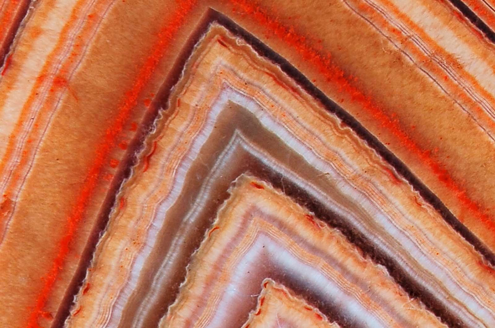
This mosaic of nine images above shows detailed texture in a conglomerate rock bearing small pebbles and sand-size particles.  The rock is at a location called "Darwin," inside Gale Crater. The camera was positioned about 4 inches (10 centimeters) from the rock. Scale is indicated by the Lincoln penny calibration target, shown beside the mosaic.

Reddish dust coats much of the surface visible in this mosaic, but the patch of rock also offers some bare patches where sand and pebble grains can be seen. Pebbles here are mostly gray, with some white in them. Some grains are somewhat translucent, and some are shiny.

Researchers interpret the sand and pebbles in the rock as material that was deposited by flowing water, then later buried and cemented into rock. Curiosity's science team is studying the textures and composition of the conglomerate rock at Darwin to understand its relationship to stream bed conglomerate rock found closer to Curiosity's landing site. A major goal for observations at waypoint stops along the 5-mile (8-kilometer) route to Mount Sharp is to piece together the relationship between rock layers at "Yellowknife Bay" in the Glenelg area, where the mission found evidence of an ancient freshwater-lake environment favorable for microbial life, and layers at the main destination on lower slopes of Mount Sharp.

The photo above shows how Curiosity is using a new technique to more quickly and safely place the  the tool-bearing turret on its robotic arm closer to the target rock. The technique, called proximity placement, allows researchers to collect data that allows them to move the turret closer if it is not yet close enough. This will enable placement of the instrument much closer to soil targets than would have been feasible without risk of touching the sensor head to loose soil.
CITES:
NASA/JPL-Caltech/MSSS, http://mars.jpl.nasa.gov/msl/multimedia/images/?ImageID=5554
NASA/JPL-Caltech/Malin Space Science Systems, http://mars.jpl.nasa.gov/msl/multimedia/images/?ImageID=5560
NASA/JPL-Caltech/MSSS, http://mars.jpl.nasa.gov/msl/multimedia/images/?ImageID=5563
NASA/JPL-Caltech/MSSS, http://mars.jpl.nasa.gov/msl/multimedia/images/?ImageID=5564
NASA/JPL-Caltech, http://mars.jpl.nasa.gov/msl/multimedia/images/?ImageID=5565

Sunday, September 29, 2013

Sable Falls Area Evening Hike -- Post 2

Today I'll post the rest of the photos from my evening hike in the Sable Falls area the other night.

Once I very carefully maneuvered my way down the face of the dune, I turned around to snap the photo below.  As you can see, the massive erosion from all the intense storms is playing havoc with the Grand Sable Banks.  Most of what is left is clay.  It was not an easy climb down.


But it was a beautiful evening.


The route I climbed down is just to the left of the newly developed spring that has cut its path down the dune.  Notice the huge boulder that worked its way free and rolled to the bottom.


The drainage patterns were quite picturesque.


Of course the rocks are always colorful.  First wet rocks just off shore...

 
Then dry rocks....
 

Another picture looking up the bank...


I'm not sure if the animal track shown below is a moose track or a deer track.  It was quite large, so I'm thinking probably moose.


 The after glow of sunset...


I have never seen so much water at the mouth of Sable River.


The only way to get across was to balance and carefully work my way across the log shown on the left below.  I did get my feet wet on the far side. 


Looking upstream at the log jam...


I tried to capture the light at Au Sable Point and was successful with my first shot.  In five more photo attempts I was not able to get the timing.


Up the steps and back to the car...

Saturday, September 28, 2013

Sable Falls Area Evening Hike -- Post 1

Last night was a beautiful fall evening with temperatures near 70 and little to no wind.  I decided at the last minute to take an evening hike in the Pictured Rocks National Lakeshore.  The closest to my house is Sable Falls, which is around a mile and a half from my driveway.  First I quickly did an internet search to find out sunset time, which right now is at 7:31.  Since it was already 7pm, I quickly grabbed my camera, hiking boots, and hiking poles and dashed off.

I took a lot of photos, so I'll post them over two days.  For this blog update, I'll include the pictures I took while walking from the parking lot to the bluff.  I had the hike all to myself -- didn't see another human being.


Fall colors are definitely late this year, but there are a few trees that have turned.


Into the sand dunes...


To the bluff...


Although the sun is setting "behind" Au Sable Point, I was able to still get some nice photos.


Looking east..


Two fishing boats drove by heading back to Grand Marais.  I was able to zoom in to get a couple of photos...


I decided to descend and walk the beach back to Sable Falls steps.  The photo below shows where I usually go down.  I have never seen so much erosion.  This was not a safe way down as some of the eroded crevices were over my head.


While contemplating whether it was safe for me to go down the dune, I captured some more photos.


Just to the west was another area that looked a little more safe.  This is where I headed down.

 
Continued tomorrow....

Friday, September 27, 2013

More Close Up Agate Photos

Today I am going to take advantage of our warm fall weather to make agate plates.  I make the plates on my sun porch so the weather has to be warm enough to mix and pour the acrylic.  Since it takes several hours to make a batch of agate plates, I need to get to the task.  So for today's posting I am including close ups of the detail of some of my agate book pictures.

Oregon Priday agate...


Another Oregon agate...


Argentina Black River agate...


Argentina Condor agate...


Botswana agate...


Brazilian agate...


Mexican Crazy Lace agate..


Mexican Laguna agate...


Another Laguna agate...


Lake Superior agate...


Brazilian sagenite agate...

Thursday, September 26, 2013

For today's posting I have miscellaneous pictures I've taken in the last few days.  First, there has been a dredging tug hanging out in the Grand Marais harbor as of late.  At first we thought it was going to dredge the channel at the entrance to hour harbor, but that is not the case.  The dredging operation is for the Little Lake Harbor, located east of Grand Marais.


After the out-of-town teens used fireworks to destroy the new playground equipment, the replacement and repairs have now been made.


In the green space across from the grocery store and next to the Post Office Museum, a new restaurant is being built by local contractor, Tim Swift.  He is expected to open the restaurant next year.


The nice fall weather is helping our garden.  Earlier this week Jamey, Lois, and I harvested a lot of tomatoes, carrots, beans, parsley, and a few peppers.


A flock of geese was hanging out down at the bay.