


The first earthquake on September 24th had a magnitude of 7.7. On 28 September the aftershock hit with a 6.8 magnitude. The earthquake resulted due to an oblique-strike-slip type motion at shallow crustal depths. The tectonics of southern Pakistan reflect a complex plate boundary where the India plate slides northward relative to the Eurasia plate in the east, and the Arabia plate subducts northward beneath the Eurasia plate. Although seismically active, this portion of the Eurasia plate boundary has not experienced large damaging earthquakes in recent history. In the past 40 years, only one significant event has occurred within 120 miles (200 km) of this event, which was a magnitude 6.1 earthquake in July 1990 that killed six people.
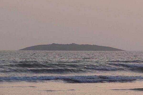
It is horrible that the earthquakes were so deadly. The power of the earthquakes can be measured in another way. It created a mud volcano and formed a brand new island that is more than 575 feet in diameter and 60 to 70 feet tall (175 by 18 to 21 meters). The new island formed around 650 feet from the coast near the town of Gwadar.


The island, called Zalzala Koh, is believed to be the result of a mud volcano that formed when deposits of frozen gas hydrates—which have a large methane content— that were buried beneath between 980 and 2,600 feet of compressed sediment (300 to 800 m). The heat and friction from the earthquake converted the gas hydrates from frozen to gaseous, which then escaped and rose to the surface through cracks in the sedimentary rock layers. Finer, loosely packed sediments also became liquid-like and squeezed up through the cracks forming the island. Locals who ventured to the new land mass shortly after it formed heard a hissing noise at one end and started a fire which was difficult to extinguish due to the large quantity of methane gas. This is not the first time new islands have formed. In fact, similar islands have appeared in the same region following earthquakes in 1945, 1999, 2001, and 2010. Because of its composition of softer sediments, the sea will erode the island completely within a few months.
Here are some more pictures of the new island.


The new island is covered in dead fish and other sea creatures that are on top of mud, sand and rock.
Cites:
http://en.wikipedia.org/wiki/2013_Pakistan_earthquake
http://en.wikipedia.org/wiki/File:Pakistan_location_map.svg
http://www.nbcnews.com/science/satellites-reveal-new-views-pakistans-earthquake-island-8C11316004
http://sincedutch.files.wordpress.com/2013/09/7-8m-earthquake-pakistan-sept-24-2013.jpg
http://quakesos.sosearthquakesvz.netdna-cdn.com/wp-content/uploads/2013/09/Screen-Shot-2013-09-24-at-18.42.50.png
http://media.emirates247.com/images/2013/09/3124669393.jpg
http://static1.emsc.eu/Images/EVID/33/335/335756/335756.global.thumb.jpg
http://upload.wikimedia.org/wikipedia/commons/thumb/e/e5/Pakistan_Earthquake_Island.png/220px-Pakistan_Earthquake_Island.png
No comments:
Post a Comment